Posts

Showing posts from July 20, 2008

Mudpits so Stinky

Image
Back to New Zealand's hydrothermal region, the northcentral part of the North Island. Since I was a child I have wanted to experience a mud pit. When I was about 5 my mother brought home a geological text about New Zealand and I was absolutely captivated by boiling pits of mud. I saw black and white photos of active volcanoes and geysers shooting off into the sky. I knew I had to go and see this with my very own eyes. Seeing photos of mudpits doesn't do them justice. It is the sounds and smells that overwhelm you once you are front of one. This particular lovely was quite large, I'd say about 40 m across and right under my balcony in my hotel room in Rotorua. I think every tourist that visits New Zealand goes to Rotorua. It is like the Las Vegas of Kiwiland. The sounds emanating from a mud pit cover quite the range. Farts, belches, hiccups, squeels, blorps, pops, burbles, everything. Oh and sounds like a woodwind orchestra sometimes. Now the smell. That seems to be more co

Impossible Place

Image
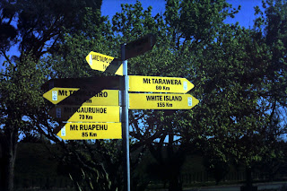
Are you kidding me?? New Zealanders live on top of active volcanoes. The town you see above is Taupo on the North Island and not only are there two active volcanoes just yonder beyond the baseball diamond, but the entire lake is a caldera lake. everything you see and well beyond is yet another huge volcano. Taupo volcano has erupted with the most violent eruption in the last five thousand years on Earth. So yeah. A little travel bag in the trunk of the car at all times, I'd say. From the signposts you can see a sampling of just a few of the many many volcanoes that occupy the central part of the North Island. Some are dormant, others active. The dark crater view with the steep sides is from the highlight of my trip, a hike into the caldera of Mt. Tarawera. When this one erupted in 1886 over a hundred people died in what was the most tragic eruption in New Zealand's human history. The blast was so tremendous that a rift structure was created at the top of the volcano, instead

Krakatau

Image
this incredible image from the IKONOS satellite comes to us from the good people at http://volcano.oregonstate.edu/ I've been staring at this image on the background of my desktop for some months now and I can't bear to change it out for a new image. I usually change every 3-4 days! So much can be seen on this volcanic cone. First of all, it is located in Indonesia, and the background history ( at least for man's span of existence) can be found at http://volcano.oregonstate.edu/vwdocs/volc_images/southeast_asia/indonesia/krakatau.html You can see every lava flow outlined clearly. Each lobe is defined. The segment of trees wiped out by the recent flow is clearly seen. The windward side clearly receives most of the energy of the waves, as there are no sediments accumulating there. On the lee side of the island, the beach deposits are clear. If the resolution allows, you can make out a narrow trail that scientists must be using to reach the summit for their gas sampling. The

Breathtaking view

Image
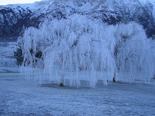
This stunning photo of trees covered in hoar frost was taken recently by Owen Naumann of New Zealand. During a road trip the car came to a quick stop at Gibbston Valley (Peregrine Winery). It is near Queenstown, on the South Island. I am struck speechless when I look at this. Such beauty.